On a Saturday i August
It was supposed to be a short trip over the mountain to Hardanger. In the evening I had traveled more than 800 kilometers over seven mountains, and some minor detours. Join me on an amazing trip through some of the best of landscapes Norway has to offer.
I awoke from a heavy rain, but consoled myself that it would stop during the morning. The weather radar on my mobile indicated so as well. Instead of pulling away, the rain stopped and formed a large red mark on the weather radar over Haglebu . Not the weather I foreseen for my motorcycle ride. I passed the day by preparing for the Saturday trip and do some maintenance in the basement.
That was yesterday; today it is supposed to clear, although it is a wet morning to day as well. I have planned to go and have a look at the Hardanger Bridge for some time. The bridge over the Hardanger fjord had its three year anniversary last week. I used to have at least one proper motorcycle ride over the mountains to the West Coast every year, now it is a long time since I have been over. Today is the time to correct this.
It is still raining lightly when I ride the gravel road down to the main road and turn right towards Bromma. Cold tires and wet asphalt, just so humid that I see tracks from cars that have driven ahead of me, do not inspire an offensive ride. As the road descends towards Bromma I notice that the tracks in front of me turns to the left side of the road. I ride cautiously into the next curve – and there in the middle of the road is the sheep. They are occupying most of the road, but there is some room to the far left.
I pass Svangtjernmyra nature reserve and when I come out of the forest and the Hallingdal Valley opens before me the asphalt is dry. The clouds are about to give way to the sun over the Bromma Fjord. This is Hallingdal at its best.
I ride Highway 7 north. At Geilo I refuel before heading for Hardangervidda. The mountain plateau is so wast, in one way it is intimate with the road curving round lakes and over hills, but on the other hand – the dramtic mountains are all in a distance. I pass Ustaoset and Haugastol, and enjoy the many S-curves after Haugastol.
I make a short break at Orteren and then make a stop at Dyratjornane and admire the Hardangerjokulen in the distance. It is nearly 14 km away, but still an impressive sight with the glacier Vestra Leirebottsskaaka facing me.
There have been signs informing about a bicycle race several places on the route from Geilo. So far, I have not seen any racing cyclists. By Dyranut I meet the first racers. Some of them start at Dyranut and ride the 55 kilometers to Geilo, while others started at Voss and ride to Geilo, a total of 2150 meters climbing on 160 kilometers distance. On my way to Fossli and Måbødalen the number of cyclist rise. By Voringsfossen, there are so many tourists and cyclists that I do not even consider stopping.
I get a stop down at Storegjel in Maabodalen while I wait for the peloton to ride through Maabotunnelen. The mountain wall on the north side of Maabodalen goes sky high, at least it feels that way, and it is an impressive sight. I meet many cyclists on the road to Eidfjord, but the lovely and varied road offers great driving despite the heavy traffic.
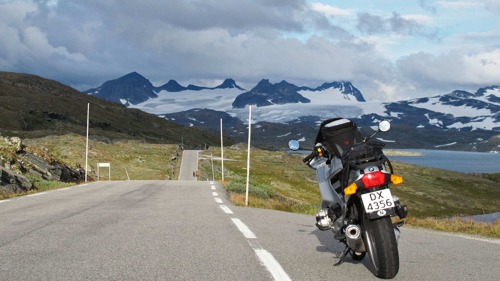
The Eidfjord Lake is shiny and dark, and so is the Eidfjord. I follow the fjord westbound and stop at the rest area and viewpoint at Bu, at the south end of the Hardanger Bridge. The bridge is an impressive construction; 1380 meters long, with a range of 1,310 meters. The two towers rises 201.5 meters in height and under the bridge is about 55 meters sailing height. Motorcycles pass the bridge free, while there is a fee of 150 kroner for passenger car. The bridge was opened on 14th of August 2013 and is Norway’s longest suspension bridge, and is among the 10 longest suspension bridges in the world.
Highway 7 ends at the roundabout in the tunnel where you enter highway 13. Here you can go right towards Odda and Haugesund or left over the bridge to Voss and Bergen. When I have crossed the bridge, I can continue through the tunnel to the lake Granvinsvatnet. I choose the other option, and go to Ulvik and makes a stop for a picture of the bridge in its entire length before I rounds Kagganeset and ride along the Osa Fjord and later the eventually Ulvik Fjord. It is this kind of roads and scenery that make this ride amazing.
In Ulvik road leave the fjord and climb the hillside towards the Espeland Lake and in the Espelandsdalen valley to the lake Granvinsvatnet where I enter Highway 13 again.
The plan is to ride to Aurland and then take the road 50 over the mountain to Hol in Hallingdal valley. At Voss, I enter the E16. By the lake Oppheimsvatnet, it is time for lunch and a break at a restarea.
Before entering the Stalheim tunnel, I enter the old road to Stalheimskleiva to the left. This is a very nice detour that also takes you around some of the tunnels on the road to Gudvangen and Aurland. The road takes you up to Stalheim Hotel and continues over the top and down into the Naeroy Valley on the other side. The road up Stalheimskleiva was completed in 1849. The first time I drove here was in the late 70s. Then it was a gravel road. Today this is a one-way road and a tourist route. The distinctive Jordalsnuten mountain and the two waterfalls, Stalheimfossen and Sivlefossen, are contributing to experience of Stalheimskleiva.
Tunnels are boring, and here there are many of them. When tunnels are 12 km long it is easy to be distracted by creative thoughts, rather than concentrating on the riding. As I exit the last tunnel before Aurland, I have decided to do another mountain, the Aurland Mountain towards Laerdal. Saturday is normally a bad day for this tour, the narrow road from Aurlandsvangen has limited capacity. Stegastein is a very popular viewpoint and today motorcycles, cars and campers fill the parking. I have already had a stop a little further down the road – in the first hairpin to the right, there is space enough to park two motorcycles – and I prefer this rather than the crowded viewpoint a little further down the road. Stegastein however is a must if you pass here only once.
I continue up the mountain, and now I am almost alone. It seems to me like most people turns at Stegastein. Aurland Mountain is wonderful today, with a clear view and perfect riding conditions. I am at the maximum height, just over 1,300 meters, almost immediately. Then the road winds its way north across the mountain. And eventually you will see the glaciers in Breheimen in a distance.
When I am in Laerdal I can head for the mountains eastbound – over Filefjell or the Hemseldal mountains, both routes will take med back to Haglebu and the mountain cottage. I decide otherwise and take to a left turn in Leaerdal, heading for the Fodnes tunnel bound and aiming for Ovre Aardal. On the other side of the Fodnes tunnel I ride east along the Aardalsfjord. The mountains along the fjord are 700 to 900 meters high and falls straight in to the fjord. There is always a special atmosphere here, and today the fjord look like a mirror reflecting the dark mountains. mountains that plunge straight into the fjord there is a separate mood into fjords here. The ride to Aardalstangen is smooth, and the small difference in height up to Aardal Lake is barely noticeable, I still have the feeling of driving by the Aardalsfjord.
In Ovre Aardal it is time to refuel. As I leave the petrol station, I decide to take three more mountains and turn left in direction of Turtagro. The Tindevegen road between Ovre Aardal and Turtagro has been one of my favorites for many years, and I have had many fine ride over here with both in cars and on motorcycles. The road has improved over the years and now it is asphalt all the way over the mountain. The most challenging part is the climb up from Ovre Aardal where the road is narrow and runs in some incredibly tight hairpins – 15 before it flattens out in Fardalen, then a few more before I continue up the valley. In the end of Fardalen valley there is another climb before I am on the mountain plateau with the Hurrungane mountains on my right. The peaks are more than 2000 meter high and today they in the clouds.
The tollbooth is located at just over 1,300 meters and the weather can be hard here. Today it is quiet and the sun is still warming. A passage costs 80 kroner regardless of vehicle type and you pay by credit card. I stop just after the tollbooth on the way down towards Berdal with road up Berdal mountain in a distance. To the right, is the Berdal glacier, and Soleibotntinden and Store Ringstind with peaks more than 2000 meters high. Behind lies the rest of Hurrungane with many more 2000 meter peaks, all wrapped up in low clouds.
I make one more stop, this time at the highest point on the Berdal mountain. Now I have a good view to the Jostedalsbreen glacier towards west, straight in front of me is the Breheimen with its glaciers. In between lies Bergsdalen and the Fortun valley that ends up by the sea at Skjolden. I ride down to the viewpoint by Hongi. Here I have a fantastic view down to Turtagro and over to the road up Sognefjellet, to the mountains Helgedalsnosi and Steindalsnosi with their tops wrapped in clouds. Further to my right is Fannaraaken and slightly more to the right are Skagastolstindan.
Now the road descends steadily towards Turtagro. It is easy to be fooled, the road is steeper than it seems to be and it is easy to get a little too fast into some of the corners. At road 55 I take to the right and starts on the climb up the Sognefjell road. I have a stop at the viewpoint Nedre Oscarshaug. Here I have a perfect view to Skagastolstindan and over to the Berdal mountain and Tindevegen road. All the highest peaks are in the clouds, but this is still a magnificent sight.
With the sun on my back enter the Sognefjellet plateau and continue eastwards. It is easy to become romantic in such surroundings. Never have I seen Sognefjellet so powerfully. The contrast from the Smorstabbreen glacier in sunshine and the Fanaraaken peak and glacier shrouded in heavy clouds make a drama you have experience to understand. I stop by Knut Wolds larvikite stone sculpture at Mefjell viewpoint. I admire the simple and powerful sculpture. It stands out in the landscape and in a way, it gives more power of the mountains.
Sognefjellhytta hotel hast ben refurbished with a modern extension since last I was here. After the hotel it is downhill and in to the Breidsaeterdalen valley, along the lake Bovertunvatnet and over to Leirdalen and Boverdalen valleys. I pass the viewpoint at the exit to Leirvassbu and continue down the valley. Then it starts raining. I have seen the dark clouds in the east for long now, but I have hoped they were dark only, not wet. Luckily, there are only showers. It has a little wet at Lom, then the road is dry again, and at Tessand I turn to the right direction Valdresflye on dry asphalt.
I stop at Lomtjonne, before the lake Lemonsjoen and put on some warmer clothes. I take something to drink and the rest of my lunch as well, before heading home. That is right, now I am on my way home – for the first time today. It is almost nine o’clock, it is getting darker by the minute, and soon it is only sky and the high clouds that have some light. I stop at the viewpoint at Vargabakkane south of Gjendesheim on my way up to the Valdresflye plateau. Low clouds hovering over Besseggen and the lake Nedre Leirungen with magical blue reflections of the bright evening sky. Further south is Mesmogtinden hardly visible, with heavy clouds and the weakening light.
On the other side of the mountain, I get rain, heavy rain. On the other side, at Beitostolen, the asphalt is dry and light return. However, it fades quickly. When I arrive in Fagernes, it is dark. I ride to Leira, and turn right towards Gol. Just before I take off, I pass a sign with an entire novel. It is too late to stop, but understood form what I managed to read that the road over Golsfjellet is closed at night from nine o’clock. It must be possible to pass this, I thin, and continue up the mountain. After a while, there is a new sign and I stop to read the whole novel. Closed at night from nine o’clock, except Thursday through Sunday. I breathe a sigh of relief. Now it is raining heavily again. Those of you who have ridden motorcycle through hairpin curves in darkness and rain knows that it is much like driving blindfolded – there is no light where you need it.
When I finally start on climb up from Bromma I have had rain on and off, but now it is definitely on. It just buckets down. Visibility is good, except in the hairpin bends. Half past eleven I park outside the cottage. I had done 800 kilometers in just over 14 hours. It feels good to think of the ride; I have had a fantastic day and I realize that I should do this more often.
Usefull links:
National Tourist Routes in Norway
Detailed map of Norway
NB! Google Maps may change a route if it includes a road that is closed (e.g. closed during the winter) at the time you are viewing the route.
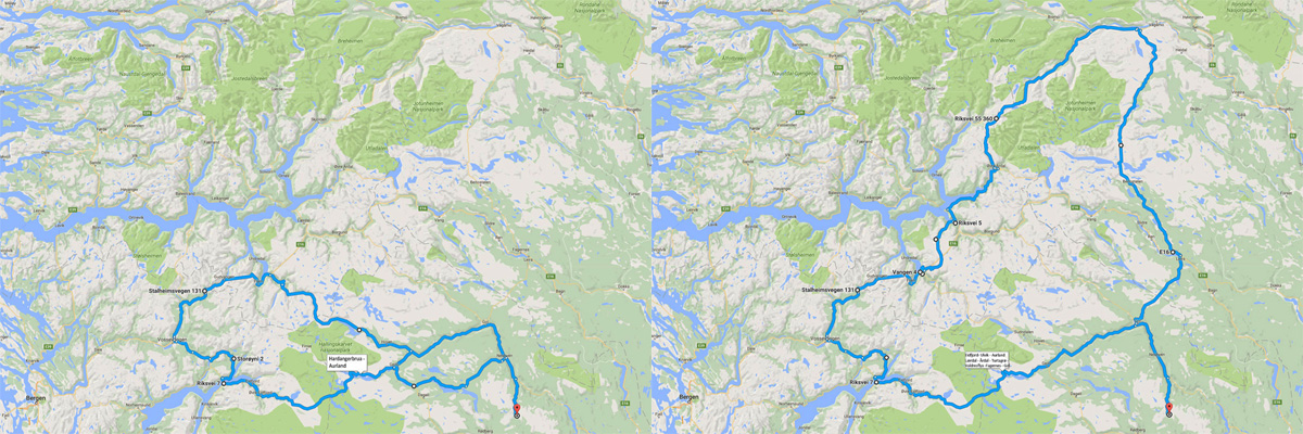 My planned route for the day to the left, the final route to the right.